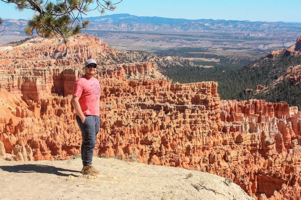
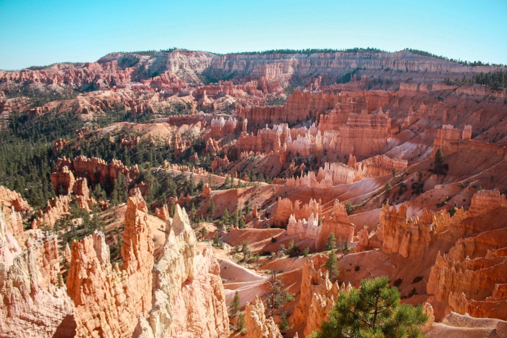
I’ve spent the better part of a decade chasing horizons across the American West, but there’s something about the first light hitting the orange minarets of Bryce Canyon that still makes my heart skip a beat. Imagine standing on the rim as the sun bleeds across a forest of stone, turning thousands of "hoodoos"—those gravity-defying sandstone pillars—into glowing embers. It’s a landscape that feels less like Earth and more like a fever dream of a master sculptor.
As we head into 2025, Bryce Canyon remains a bucket-list titan for a reason. Whether you’re a seasoned trekker looking to push your limits on the Fairyland Loop or a family seeking high-reward views with minimal sweat, this park delivers. If you’re short on time, the best easy hikes for beginners are the Sunset to Sunrise Point trail (1 mile) and the Mossy Cave trail (0.8 miles). If it’s a desert oasis you're after, head straight to the Mossy Cave Trail in the northern section—it’s the only place in the park where you’ll find a waterfall and a lush, moss-filled grotto. For that quintessential "I’m actually in Bryce" moment, the Navajo Loop and Queen’s Garden Trail is my top recommendation for 2025; it’s the most iconic way to see Thor’s Hammer and the towering fins of Wall Street in a single 2-to-3-hour trek.
Know Before You Reach the Trailhead
Before you lace up your boots, let’s talk logistics. Bryce isn’t your typical desert. While Zion or Arches might bake you at lower elevations, Bryce Canyon sits on the high-altitude Paunsaugunt Plateau. We’re talking about an elevation range that spans 1,221 feet, starting at a crisp 7,894 feet at the Visitor Center and climbing to a staggering 9,115 feet at Rainbow Point.
I’ve seen plenty of fit hikers gasping for air because they underestimated the thin atmosphere. Take it slow, hydrate more than you think you need to, and always pack a layer—even in the height of summer, temperatures rarely top 80°F, and mornings can be downright chilly. If you’re visiting in winter, don’t even think about it without traction spikes and a check on snow chain requirements for your vehicle. Finally, keep it wild: Bryce is home to fragile biological soil crusts and curious wildlife. Stick to the designated trails and Leave No Trace.
Easy & Family-Friendly Trails (High Reward, Low Effort)
1. Mossy Cave Trail
If you want to see a side of Bryce that isn’t just dry rock, this is your spot. Located along Highway 12 outside the main park fee area, this trail follows a small fork of the Sevier River. It’s the primary destination for anyone hunting for waterfalls in Bryce Canyon. You’ll reach a split where one path leads to a dripping mossy grotto (which turns into giant icicles in winter) and the other leads to a surprisingly robust waterfall.
- Distance: 0.8 miles round trip
- Elevation Gain: 150 ft
- Difficulty: Easy
- Time: 45 minutes
Marcus’s Pro Tip: Parking here is a nightmare after 10:00 AM. Hit this trail at sunrise or wait until an hour before sunset for the best light on the waterfall.
2. Sunset to Sunrise Point (The Rim Trail)
This is the "greatest hits" reel of Bryce Canyon. If you only have thirty minutes, walk this paved section of the Rim Trail. It offers legendary views of the Bryce Amphitheater, including the famous Thor’s Hammer. It’s also one of only two designated dog-friendly hiking routes in the entire park, making it a must-do for those traveling with four-legged companions.
- Distance: 1 mile point-to-point
- Elevation Gain: 40 ft
- Difficulty: Easy / Wheelchair Accessible
- Time: 30–60 minutes
3. Bristlecone Loop
To find the oldest living things in the park, you have to drive to the very end of the park road to Rainbow Point. At 9,115 feet, the air is thin and the vistas are infinite. The Bristlecone Loop takes you through a forest of ancient Bristlecone Pines—some of which have been standing for over 1,800 years.
- Distance: 1 mile loop
- Elevation Gain: 200 ft
- Difficulty: Easy
- Time: 1 hour
Moderate Hikes: Entering the Amphitheater
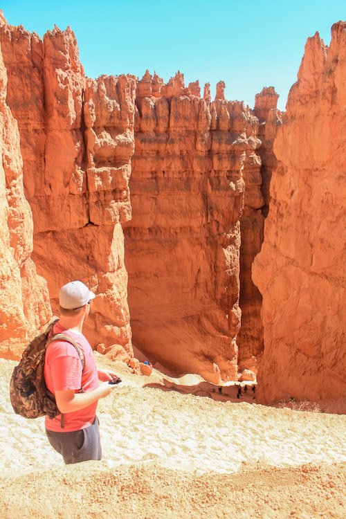
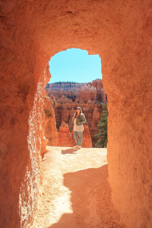
4. Navajo Loop & Queen’s Garden Trail
This is, bar none, the most popular hike in the park—and for good reason. I always suggest starting at Sunset Point, descending through the "Wall Street" side (check for seasonal closures, as it often shuts in winter due to rockfall), and climbing back up through Queen’s Garden. Descending into Wall Street feels like entering a cathedral of stone; the switchbacks are tight, the walls are hundreds of feet high, and a pair of lone Douglas firs reach for the sliver of blue sky above.
- Distance: 2.9 miles (combined loop)
- Elevation Gain: 600 ft
- Difficulty: Moderate
- Time: 2–3 hours
As you transition into the Queen’s Garden section, keep your eyes peeled for the "Queen Victoria" formation—a hoodoo that looks uncannily like the monarch overlooking her stony subjects.
5. Tower Bridge
If you want to escape the Navajo Loop crowds but still see impressive geology, Tower Bridge is your answer. The trail drops down from the rim through the "Chinese Wall"—a massive fin of hoodoos—and ends at a natural bridge that looks strikingly like the London landmark. It’s a steady climb back up, so save some water for the return trip.
- Distance: 3 miles round trip
- Elevation Gain: 950 ft
- Difficulty: Moderate
- Time: 2 hours
Challenging Expeditions for Seasoned Trekkers
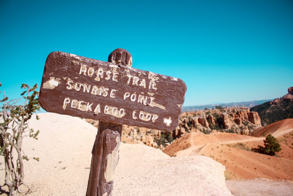
6. Peekaboo Loop (The Figure-8 Challenge)
This is where Bryce gets serious. Often combined with the Navajo and Queen’s Garden trails to form the "Figure-8," the Peekaboo Loop is a rollercoaster of elevation. You’ll weave through the heart of the amphitheater, passing the Hindu Temple, the Fairy Castle, and the Wall of Windows. Note that this trail is shared with mule tours, so be prepared to yield to our equine friends and watch your step!
- Distance: 5.5 miles loop
- Elevation Gain: 1,479 ft
- Difficulty: Strenuous
- Time: 3–4 hours
7. Fairyland Loop
If you want the "immersion" experience without the crowds, Fairyland is my personal favorite. It starts at Fairyland Point (before the park entrance station) and circumnavigates Boat Mesa. The trail is long and features constant elevation changes as you drop in and out of canyons. It feels more desolate, more rugged, and infinitely more peaceful than the main amphitheater.
- Distance: 8 miles loop
- Elevation Gain: 1,900 ft
- Difficulty: Strenuous
- Time: 4–5 hours
8. Sheep Creek / Swamp Canyon
For the backcountry enthusiast, this loop offers a break from the orange-and-red monotony. You’ll find more ponderosa pines and Douglas firs here, providing a lush green contrast to the pink cliffs. It’s a great spot for bird watching and catching a glimpse of the park's quieter, forested side.
- Distance: 4 miles loop
- Elevation Gain: 647 ft
- Difficulty: Moderate to Strenuous
- Time: 2.5 hours
Pro Photography Tips: Capturing the Hoodoos
You didn’t come all this way just to take blurry phone shots. To truly capture the soul of Bryce, you need to understand the light.
- The "Civil Twilight" Secret: Most people pack up their tripods the moment the sun dips below the horizon. Big mistake. "Civil Twilight"—the 30 minutes after sunset—is when the canyon’s shadows soften and the orange rock seems to glow from within due to reflected light.
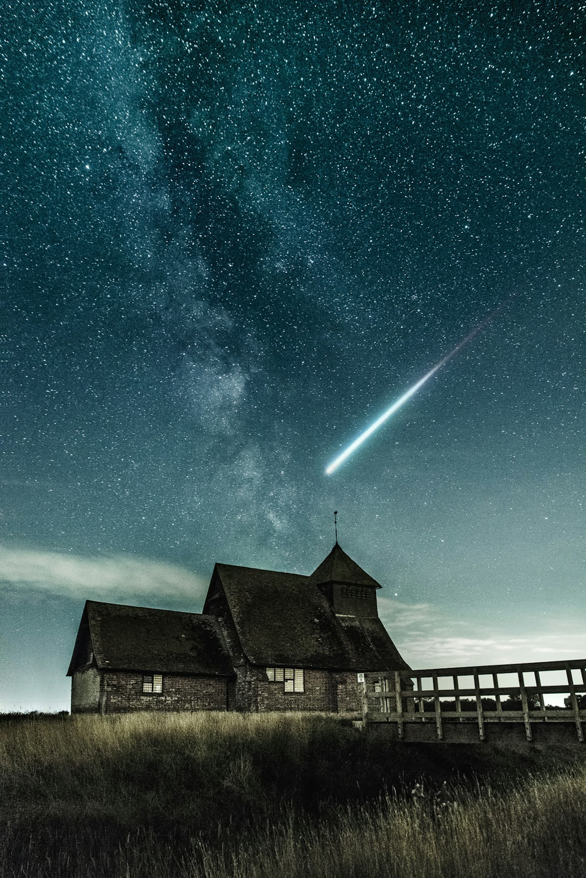
- Astrophotography: Bryce is an International Dark Sky Park. If you’re here during a New Moon, point your lens south for the Milky Way. If there’s a Quarter Moon, use that natural light to "light paint" the foreground hoodoos while keeping the stars sharp.
- Telephoto Perspective: Don’t just shoot wide. Use a zoom lens (70-200mm) to compress the rows of hoodoos, making them look like a dense, crowded city of stone.
2025 Logistics & Trip Planning
Getting Around
The park's free shuttle system is your best friend. From May through October, parking lots at popular trailheads like Sunset and Bryce Point fill up by 9:00 AM. Leave your car at the shuttle hub in Bryce Canyon City and ride the bus. It’s frequent, free, and keeps the park’s air clean.
Where to Stay
- In the Park: The Lodge at Bryce Canyon is historic and puts you steps from the rim. Book at least 6–12 months in advance.
- Budget-Friendly: Look at Panguitch (about 30 minutes away). It’s a charming Western town with cheaper motels and great local diners.
Packing Essentials
I never hit a Bryce trail without a 3-liter water bladder, trekking poles (your knees will thank you on the Navajo switchbacks), and a breathable windbreaker. The weather can swing 30 degrees in an afternoon.
Bryce Canyon Hike Comparison Table
| Trail Name | Distance | Elevation Gain | Difficulty | Best For... |
|---|---|---|---|---|
| Mossy Cave | 0.8 mi | 150 ft | Easy | Waterfalls & Families |
| Rim Trail | 1-11 mi | Varies | Easy | Iconic Views & Dogs |
| Bristlecone Loop | 1.0 mi | 200 ft | Easy | Ancient Trees |
| Navajo / Queen's | 2.9 mi | 600 ft | Moderate | The Ultimate Experience |
| Tower Bridge | 3.0 mi | 950 ft | Moderate | Unique Arches |
| Peekaboo Loop | 5.5 mi | 1,479 ft | Strenuous | Photographers / Challenge |
| Fairyland Loop | 8.0 mi | 1,900 ft | Strenuous | Solitude & Immersion |
| Swamp Canyon | 4.0 mi | 647 ft | Moderate | Backcountry Vibe |
FAQ
Q: Can I see the waterfall in Mossy Cave all year round? A: Yes! However, in peak summer, the flow might be lower, and in winter, it often freezes into a spectacular ice pillar. The "moss" is most vibrant in late spring.
Q: Is Bryce Canyon better than Zion for hiking? A: It’s different! Zion is about looking up from the canyon floor at massive walls. Bryce is about looking down into an intricate maze. Bryce is generally cooler and less crowded than Zion’s main canyon.
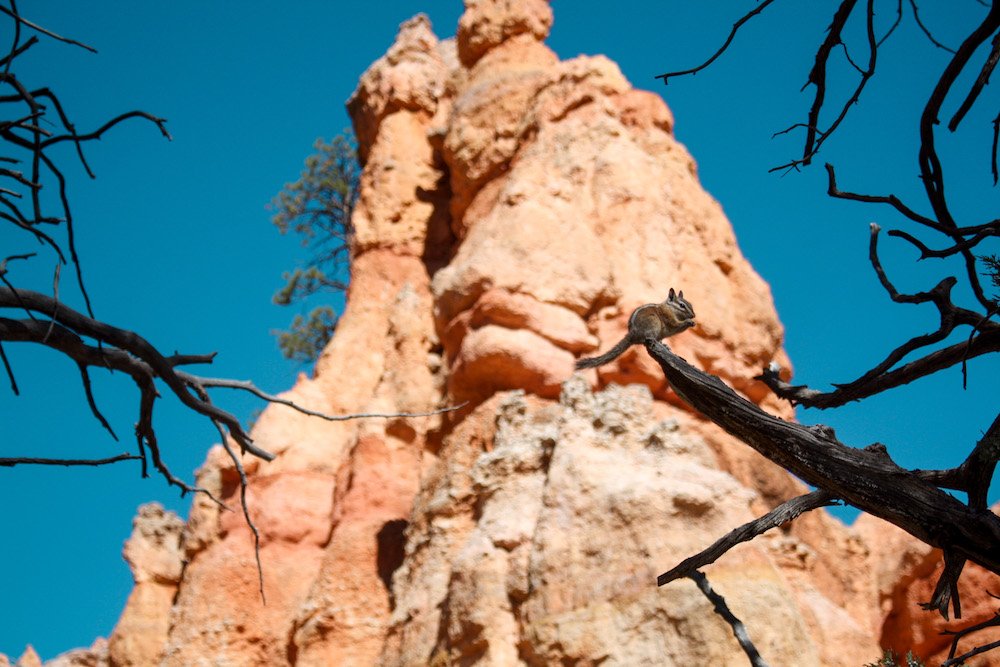
Q: Are there any dangerous animals on the trails? A: You might see mule deer, pronghorn, or the occasional short-horned lizard. While mountain lions and black bears exist in the park, they are incredibly elusive. The most "dangerous" animal is often the chipmunk—don't feed them, as they can bite and carry diseases!
Ready to Explore?
There is no place on this planet quite like Bryce Canyon. Whether you’re standing in the shadow of Thor’s Hammer or listening to the wind whistle through 1,800-year-old pines, this park demands your attention. So, grab your gear, respect the trails, and I’ll see you at the rim.